Menu
Social media
Sections
03 May 2026, 18:44
Amazing South: a mysterious Black Sea island
Ця стаття також доступна українською14

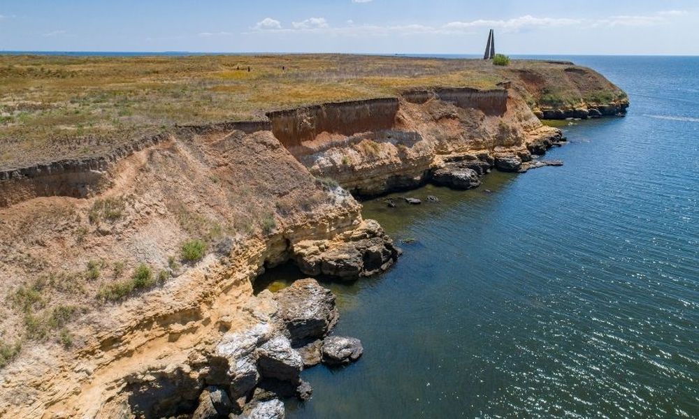
Berezan Island. PHOTO: koblevo.live
Berezan is an uninhabited island in the Black Sea in the Mykolaiv region, located on a coastal shoal that stretches from Cape Adzhiyask and the western shore of the Berezan Estuary. The island is located 2 kilometers from the Black Sea coast and 7 kilometers from the mouth of the Dnipro-Bug estuary. The western shore of the island is washed by the waters of the Rybakivsky Bay, on the coast of which is the resort area of Rybakivka, which also has ancient roots. Berezan is part of the Olvia Reserve of the National Academy of Sciences of Ukraine.
Berezan will be the subject of Intent 's next story in the series "Amazing South".
The "brother" of Zmiinyi Island
The island of Berezan is a unique natural and geographical object, as it is one of the only two true mainland islands in the entire northern part of the Azov-Black Sea basin. Berezan covers a small area (approximately 23.6 hectares) and has an elongated shape. The island is up to 900 meters long and varies in width from 210 to 385 meters in different areas.
The island is based on a massive limestone slab. The surface is predominantly flat with steppe landscapes and steep, sometimes steep banks, which in the southern part of the territory reach a height of 21 meters above sea level. It is known that the island used to be a part of the mainland coast, a peninsula formed by the right bank of the Dnipro River mouth and the left bank of the Tuzly Valley, and was connected to the land by a narrow strip. Geographical changes are associated with repeated fluctuations in the Black Sea level. Over time, the massive limestone slab was eroded by sea water and the path connecting the land and the peninsula gradually became submerged. The connection between the mainland and the island remains to this day in the form of an underwater sand spit.
The rocky shores of Berezan Island. PHOTO: pravdapost.com
Scientists suggest that in ancient times the island had a much larger area. And this is not surprising, because even today every year the sea absorbs from 5 to 50 cm of its surface.
There are two versions of the origin of the island's modern name. According to the first one, the ancient Greeks who colonized this region called Berezan Borysfen, after the Greek name of the Dnipro River. The Ottomans, who later captured the island, called it the consonant phrase "Buryu-Uzen-Ada," which translates from Turkic as "the island of the wolf river." It was probably named so because of the wolf packs that lived in the valley of the neighboring river.
According to another version, the name of the island was given by the Scythians: it comes from the Iranian word "berezant," which means "high." This is explained by the fact that Berezan rises significantly above sea level. Later, the Slavs reinterpreted this name and associated it with the consonant word "birch". The estuary that washes the shores of the island and the river that flows into this estuary were named after it.
It should be noted that two main rivers flow into the Berezan Estuary near the island: The Berezan flows into the Berezan Bay of the estuary and the Sasyk flows into the Sasyk Bay of the estuary. A small river, the Kovakyn, also flows into the estuary at the entrance.
Ancient times: ancient Greek Borysfen
Today, Berezan is deserted, but archaeologists believe that in ancient times it was a bustling place. Although there is virtually no information about the pre-Greek life of the island, at the beginning of the XX century burials were found on the territory of Berezan, which scientists attribute to the Paleolithic era. A piece of silicon was also found, which could be the remnant of a silicon knife.
Ruins on the island of Berezan. PHOTO: khers-on.com
Some of the oldest documented archaeological finds point to the existence of one of the first colonial Greek settlements in the Northern Black Sea region, Borysfen, in the late VII century BC. This fact is evidenced by various artifacts discovered during the excavations: the remains of stone buildings, streets and burials, ancient coins, household items, amphorae, and other historically valuable objects dating from the VII to III centuries BC.
When exploring new lands, the Greeks first of all built a temple to Aphrodite, the goddess of love, beauty, and fertility. Borisfen was no exception. In the 90s of the last century, archaeologists found the foundation of the sanctuary and figures of gods, as well as objects related to the cult of Aphrodite, such as a dove and a turtle shell. In addition to the foundation, the sacrificial stone was also preserved. Under the ground, archaeologists have excavated underground structures connected by numerous tunnels and passages.
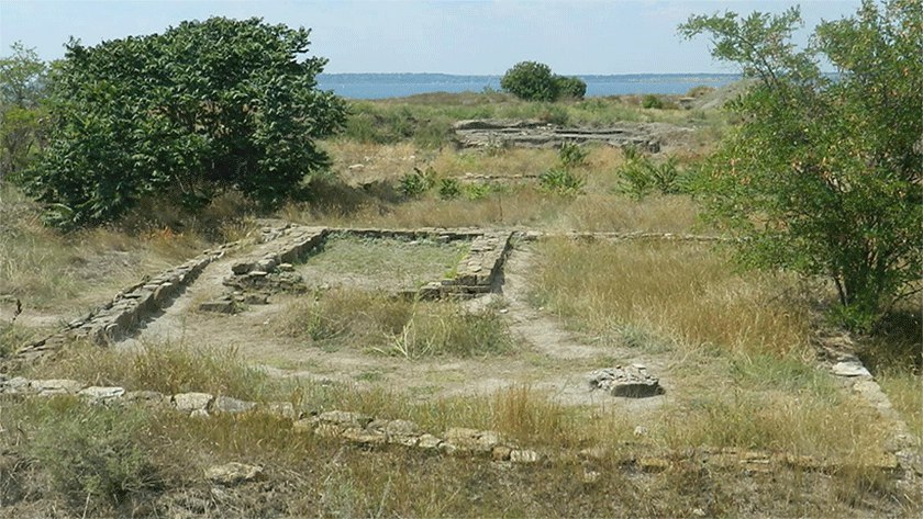
The foundation of the temple of Aphrodite. PHOTO: odportal.com.ua
The findings suggest that the heyday of Borysfen was in the VI-V centuries BC, the period when it existed as a peninsula. It was then that the center of the region was located here, where the inhabitants were engaged in fishing, farming, and metalwork. Later, Borysfen competed with Olbia, which was actively developing at the time. Most Greeks moved there.
Berezan in the Middle Ages
In the times of Kyivan Rus, the island appeared in historical sources under the name Dolskyi or Bilyi. In some tenth-century Greek sources, Berezan appears as the island of St. Eleutherius. This name can be found, for example, in a treaty between the Kyivan prince and the Byzantine emperor of 944. Historians believe that this name is connected with the legend of the burial of the Chersonese bishop in the sixth century.
It is known that sailors in the Middle Ages used Berezan as a transit point on the trade route "from the Varangians to the Greeks." The only known Scandinavian funerary stone of the X-XI centuries with a runic inscription found on the island confirms the presence of the Vikings in this area.
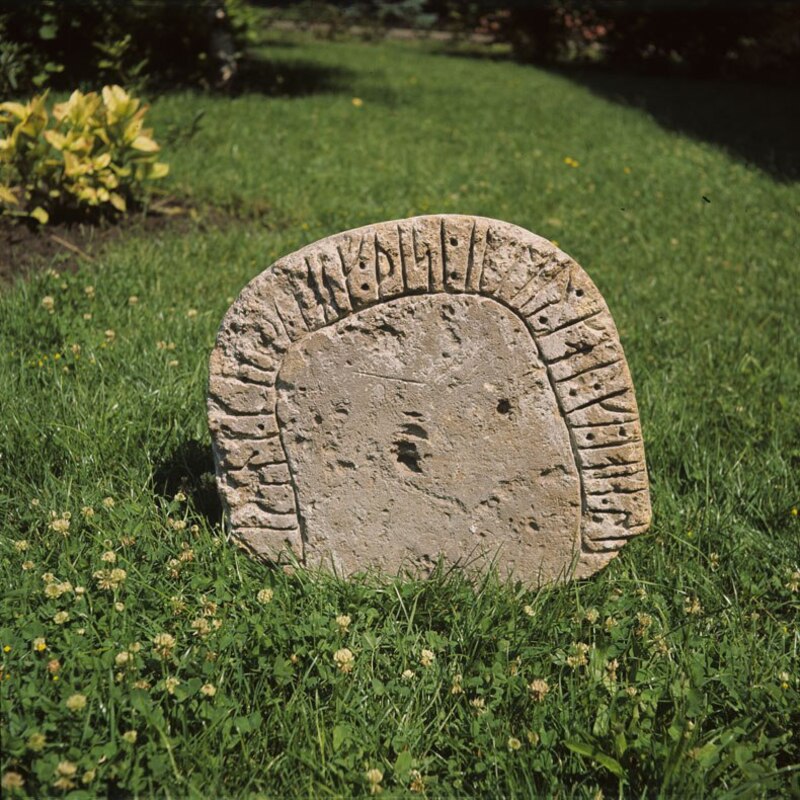
The Berezan rune stone. PHOTO: upload.wikimedia.org
In the XV-XVI centuries, the island's rulers were constantly changing. It was under the jurisdiction of the Duchy of Lithuania, part of the Kingdom of Poland, and ruled by the Crimean Khanate. However, the territory of Berezan was not settled due to the lack of drinking water sources.
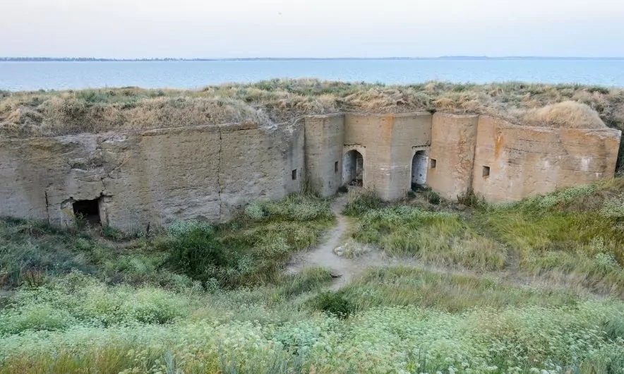
Berezan is the key to Ochakiv
In the eighteenth century, Berezan gained strategic importance and became part of the fortification triangle of the exit from the Dnipro Estuary - Achi-Kale (Ochakiv), Kylyn-Burun (Kinburn), and Biryuzen-Ada. The Turks built a fort in the southern part of the island, the remains of which, in the form of an earthen mound and the moat of the main bastion, can still be seen today. In the northern part of the island, the stone bastions of the coastal battery were erected, which served to cover the ships of the Achi-Kale rowing flotilla.
During the Russo-Turkish War in November 1787, the Turkish fortifications of Berezan were captured by the Black Sea Cossacks led by the Kosh Ataman Anton Holovaty. 800 Cossacks on small boats, armed with small cannons, attacked the coastal battery and then the fortress. It was the capture of Berezan that gave the "green light" to the invasive actions of Potemkin and his army, which led to the general attack on Achi-Kale (Ochakiv).
On Potemkin's order, after the occupation of Berezan, the fortress was liquidated because military engineers considered it outdated and not spacious enough for guns. However, Emperor Paul I ordered the fortress to be restored. A small garrison of 25 people was stationed here. From 1800 to 1825, work began on the fortification of Berezan: the bastions in the north and the Turkish fort in the south were restored. The basis of the fort was a hexagonal bastion with an area of 2200 square meters, surrounded by a wide moat and rampart, which are partially preserved today. In 1825, the fortress was liquidated again, and the garrison and state property were moved to Ochakiv.
In the early twentieth century, the military garrison returned to Berezan. The purpose of the return was to create an experimental fortress by order of the military department to test long-range naval artillery.
Finds on the island
Thanks to archaeological excavations on the island, it was possible to discover:
- Banknotes - arrow coins, dolphin coins, coins depicting Borisfen, etc.
- Figurines - a dove, Aphrodite, Apollo, etc.
- Household items made of ceramics and ivory.
- A tombstone with runic signs. Scientists deciphered the inscriptions and found out that the slab was installed at the burial site of the Viking Karl. The runic stone is now in the Odesa Archaeological Museum.
- The dishes are jugs, amphorae, and bowls.
The island of Lieutenant Schmidt
Berezan is also called the island of Lieutenant Schmidt. It served in the Black Sea Fleet. In the early twentieth century, the sailor led an uprising in Sevastopol in support of the revolution, for which he was sentenced to death along with three sailors. The sentence was carried out in 1906 on the island of Berezan.
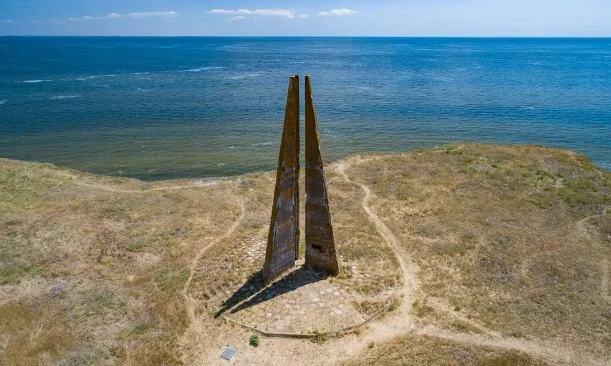
Obelisk in honor of Lieutenant Schmidt. PHOTO: khers-on.com
In Soviet times, a 15-meter-high memorial stele to Lieutenant Schmidt and the executed sailors was erected at the highest point of the island. It consists of three pylons stylized as sails, symbolizing the sails of the cruiser Ochakiv. Although the obelisk's slabs are set at equal angles, only two of them are always visible from any angle.
Interesting facts about the island
- During its existence, Berezan has had many historical names: in Greek times it was called Borysfen, in the Middle Ages it was called Dolskyi, Bilyi. The Byzantines called it the island of St. Eleutherius, and during the Crimean Khanate, the Turks gave it the name Ozibek.
- According to ancient Greek legends, the island of Berezan was home to the sanctuary of Achilles, who was honored as the "Lord of Pontus."
- Recent research on the island of Berezan shows that the stages of construction of Borysfen are similar to the construction of the colony city of Syracuse in Sicily. Initially, the colonists lived in dugouts or half-dugouts, and then permanent capital buildings appeared.
- One of the most significant archaeological finds in Berezan is a bronze cross-encolpion (pole) from the late twelfth and early thirteenth centuries. This discovery suggests that Slavs lived on the island at that time, interacting with Kyivan Rus and professing Christianity.
- According to some researchers, it was Berezan Island that became the prototype of the island of Buyana, depicted by Alexander Pushkin in The Tale of Tsar Saltan.
- Berezan Island is shrouded in legends and mysteries. There is a version that in ancient times the ancient civilization of Arata was located here, which is why the island was considered a kind of place of power.
- There are no fresh water sources on Berezan Island, which is why in ancient times this place was practically unsuitable for permanent residence.
- The process of erecting the monument in honor of Lieutenant Schmidt remains a mystery. It is still unknown how such a large-scale structure was erected without special equipment. It is also worth noting that there is no power supply on the island.
- There is an old lighthouse on Berezan that helps ships navigate near the mouth of the Dnipro-Bug estuary. It is an important historical and navigational structure on the island. However, the lighthouse is not the highest point - it is inferior in height to the monument to Lieutenant Schmidt.
- Lieutenant Schmidt's son was with him during the arrest, but the boy was released. In this regard, various "children of Lieutenant Schmidt" began to appear, asking for money to fight the tsarist regime. This story is well told in the novel The Golden Calf.

Lighthouse on the island of Berezan. PHOTO: koblevo.live
How to get to the island
The island of Berezan is located in the Black Sea off the coast of Mykolaiv region and is clearly visible on the map. It is not far from the town of Ochakiv and the villages of Rybakivka and Koblevo (on the border with Odesa Oblast). The island is bordered by the Black Sea to the south and west, the Bug River to the east, and the northern part is located near the mouth of the Dnipro River.
The main point of departure to the island is the village of Rybakivka in Mykolaiv region, which is the closest - 4 km from the island. Alternative points are Ochakiv or Luhove. Before the start of Russia's full-scale armed aggression against Ukraine, boats were constantly going to the island from these settlements.
It is worth knowing!
Due to the aggression unleashed by Russia against Ukraine, mine danger and proximity to the front line, as of spring 2026, visits to Berezan Island are extremely limited and often impossible. The island is located very close to Ochakiv, which is regularly shelled, making tourist trips life-threatening. Therefore, official tours, which were held until 2022, are not currently being organized. Before planning any trips in this direction, be sure to check the information from the Mykolaiv Regional State Administration regarding the ban on visiting water bodies and the coastal zone.
Юлія Сичова