06 November 2026, 18:50
"The First Emoji" and Petroglyphs: Alla Glavenchuk on the Discoveries in the Mykolaiv Region
Ця стаття також доступна українською

Alla Glavenchuk during an expedition to Velykyi Island. PHOTO: Oksana Hrytsyuta
Alla Glavenchuk, a research associate at the Odessa Archaeological Museum of the National Academy of Sciences of Ukraine, talks about a recent expedition to Velykyi Island on the Southern Bug River near Pivdennoukrainsk. We’ll discuss the mysterious petroglyphs and new discoveries at “places of power,” as well as the repressed expedition of the 1930s.
Alla, tell us, where exactly did the research take place, and why was Velykyi Island on the Southern Bug River, near Pivdenno-Ukrainsk, chosen for the expedition?
The story began two years ago. Local historians Vasyl Selyavin and Oleksandr Shiva, who study the history of the Pobuzhzhia region, noticed petroglyphs on the granite cliffs of Velykyi Island. Vasyl told me about it, took a photo of the discovery with his phone, and sent it to me.
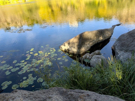
A fish-shaped rock on Velykyi Island. PHOTO: Oksana Hrytsyuta
The photo looked promising, but nature and the light falling on the rocks can create fanciful patterns. To dispel any doubts, local historians enlisted the help of Larisa Minina, a journalist from Southern Ukraine, who brought high-quality equipment; she took nearly a hundred very high-quality, detailed photos. The images clearly looked artificial, as if they had been deliberately created. Four months later, we organized a mini-expedition there to investigate and examine everything on site.
We’re talking about the granite cliffs on Velykyi Island (also known as Kryvyi), located in the middle of the Southern Bug River between the villages of Kostiantynivka and Bohdanivka. Ancient magmatic processes once raged there, resulting in the formation of granite massifs. The island itself is half composed of cliffs and boulders, and half of flat terrain where black soil eventually formed. In fact, these are two adjacent islands, Malyi and Velykyi, which can be crossed on foot, although today both are more commonly referred to simply as Velykyi or Kryvyi Island.
What exactly did you find during that initial visit?
At that time, we confirmed the presence of two distinct zoomorphic images on the walls and overhangs of the cliffs (interpretations of exactly what was depicted there vary; it depends on the observer’s imagination), as well as drawings of fish in a natural granite ravine. We found two more images. But the main surprise was something else: beneath one of the rocks, we found a pebble that had been shaped into an anthropomorphic form.
Pebbles are formed through prolonged tumbling by water, a process that takes hundreds or even thousands of years. The find was lying beneath a rock on a high point of the island, where water could not physically have carried it there and tumbled it. It is therefore clear that a human brought the pebble there. Laboratory analysis revealed that, in addition to giving this natural pebble a general anthropomorphic shape, a whole series of images had been etched onto it: figures of animals (a ram or sheep with drooping ears, a fish, a dolphin) and a peculiar “primitive emoji” can be discerned there.
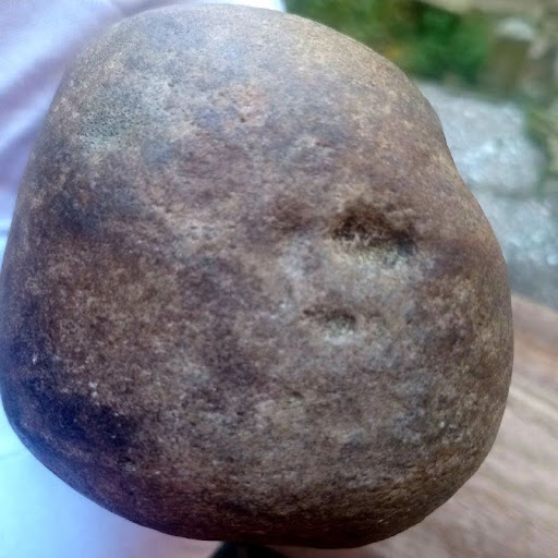
Anthropomorphic pebble with a “smiley face.” PHOTO: Nata Chernetska
It took two years before we were able to assemble a full-scale expedition to explore these rocks on site, document the petroglyphs, and search for artifacts beneath the layers of soil that would help date them. After all, it’s impossible to directly date the petroglyphs on the rocks by themselves. We can only make assumptions based on accompanying finds: pottery or flint tools.
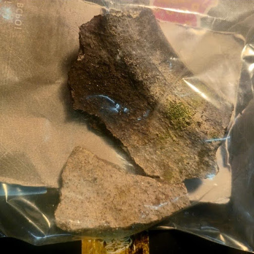
Pottery shards found during the expedition. PHOTO: Nata Chernetska
Has this island been studied by archaeologists before?
Yes, but its history is full of drama. The island was first explored in 1928–1933 by the renowned Boheska Novobudovna Expedition led by Fedir Andriyovych Kozubovskyi. Teodosi Mykolayovych Movchanivsky and other scholars from Kyiv and Odesa were also active participants. They studied the entire Pobuzhzhya region—from the Vinnytsia and Odesa regions to the Mykolaiv region—in connection with the planning of a future hydroelectric power plant. On Velykyi Island, while exploring the upper plateau, they found flint chips and fragments of ceramic pottery dating back to the Neolithic period. Today, these artifacts have been lost.
The fate of this expedition was tragic. In the 1930s, most of its participants fell victim to Stalinist repressions and perished, including the leaders themselves—Kozubovsky and Movchanivsky. Among the few who were repressed but survived was the renowned historian and geographer Fedir Yevgrafovych Petrun from Odesa—the father of our distinguished geologist and petrographer Viktor Fedorovych Petrun, who later also worked in the Pobuzhzhia region for decades.
As a result of the repression, the researchers’ names were “erased” from the public sphere and people’s memories; their manuscripts and publications were destroyed, and the expedition’s finds from various archaeological sites in the Pobuzhzhia region were scattered across the collections of institutions in Kyiv (the National Museum of the History of Ukraine, the Institute of Archaeology of the National Academy of Sciences of Ukraine). Much of this material is now considered lost, due, among other things, to World War II. However, it is possible that some of these finds have been partially preserved at the Odesa Archaeological Museum. The diaries of the expedition members, which have not yet been fully studied, contain references to the examination of the rocks in the Pobuzhzhia region. It is possible that the researchers also saw drawings on Velykyi Island. However, the published materials contain only information about the petroglyphs they saw on the rocks in this area, but not on the island. These inscriptions and drawings in the form of crosses, discovered by members of the Boges Expedition near Hard (or perhaps within the tract itself), were dated primarily to the Middle Ages and the Cossack era.
Subsequent archaeological research (surveys and excavations) on Velykyi Island was conducted in the 1980s by Kyiv archaeologist Mykola Tykhonovych Tovkailo and Mykolaiv researcher Viktor Mykolayovych Fomenko. On the plateau where the Kozubovsky expedition had found archaeological materials in the 1930s, they established excavation sites covering a total area of approximately 30 square meters and uncovered two layers of archaeological materials dating to the Neolithic and Eneolithic periods: fragments of several ceramic vessels, as well as various flint and stone tools. The site where the excavations took place is a relatively flat plateau without any cliffs. It is located in the central part of the island, some distance from the cliffs with petroglyphs that we explored this year.
Please tell us in detail about this year’s expedition. How was it organized, and what did it uncover?
This year, in October, we finally made it there. It was a joint expedition organized by the Odessa Archaeological Museum and the Petro Mohyla Black Sea National University. Overall leadership was provided by Leonid Smirnov, head of the (Laboratory of Archaeology and Ethnology) at Petro Mohyla Black Sea National University, Leonid Smirnov, who is responsible for identifying sites in the Mykolaiv region that are falling into ruin and require urgent preservation.
Local historians helped organize the expedition: Vasyl Selyavin, Oleksandr Shiva, Larisa Minina, as well as local businessman Yuriy Levytskyi, who assisted with lodging and boat transportation to the island. All of them are members of the nonprofit organization “Gard Tourist.” We are very grateful to them for their help and support. Oleksandr Shiva also participated directly in our expedition on the island.
Our task was to take high-quality photos and take various measurements. We accomplished all of this. This year, new zoomorphic petroglyphs were discovered. One of them was spotted by Vasyl Selyavin.
In addition, we dug several test pits. In the first pit, the rock crumbled immediately, so we found nothing. But in the other two pits, beneath the rock face with the petroglyphs, a surprise awaited us.
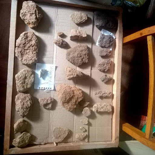
Finds in one of the test pits on Velykyi Island. PHOTO: Nata Chernetska
We discovered a layer of ancient artifacts—split stones resembling sandstone that people had deliberately brought to the base of the rock. In particular, we found a large pebble made of this material with a chip on one side. This indicates that the material was “tested”: ancient people examined its structure, observed how it split, and determined whether it was suitable for use. Preliminary analysis suggests these tools resemble artifacts from the Early or Middle Paleolithic: hand axes for butchering animal carcasses and preparing food, scrapers, and flakes.
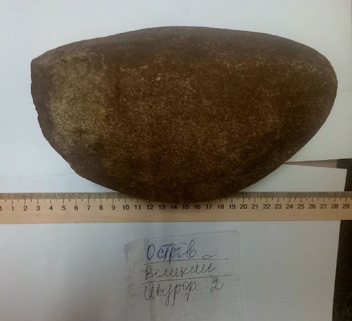
Pebbles with traces of “testing” from a test pit on Velykyi Island. PHOTO: Nata Chernetska
These finds were embedded in a layer of aeolian soil (dust deposited by the wind in ancient times), covered by granite debris that preserved the cultural layer. We collected soil samples for geologists and geographers to determine, if possible, the exact age of the deposits.
Further research at this site could be promising. The conditions for ancient people to live here are practically ideal: a fairly spacious clearing, protected on both sides by high cliffs, as well as a cave grotto with an entrance from the clearing. In other words, this could have served as a shelter or dwelling.
Today, the cave is filled with soil deposits, but it is clear that its height reaches approximately 1.2–1.5 meters. Ancient people, who were relatively short, could have felt comfortable here, sheltering from the elements. Even people of our height can fit inside…
Near the rock face with petroglyphs—where an anthropomorphic pebble was found two years ago—another pebble was discovered 2–3 meters from the first find, bearing traces of further processing, remnants of ochre, and partially calcified. Judging by their appearance and the circumstances of their discovery, both of these pebbles are so-called “churingas,” which were used as sacred objects in ancient societies.
You also mentioned the exploration of the grotto and the finds made of vein quartz. What are these objects?
Another group of petroglyphs is located practically right next to the site of the finds we just discussed. There, zoomorphic drawings were discovered on another granite wall, on the overhang above it, and inside a natural, shallow granite “trench” located below, beneath the wall and the overhang. Nearby there is also a small granite grotto with a low ceiling, into which only a very slender person can squeeze. You can only stay there while lying down.
I spent half a day near this grotto, lying on my stomach and rolling stone objects out with a modified stick. Most likely, ancient people left them there for safekeeping. In the grotto and nearby, I collected objects from the surface that resembled artifacts and man-made objects (i.e., natural objects that are not typical of this area and were brought here by humans).
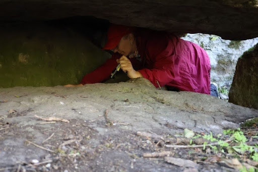
Alla Glavenchuk during the expedition. PHOTO: Oksana Hrytsyuta
First, there is vein quartz, which is abundant in the Pobuzhzhia region. Ancient people made extensive use of it. Among the latest finds are some extremely interesting objects. For example, we discovered a complete set consisting of a quartz mortar and a pebble made of vein quartz, on which distinct traces of red ochre remain.
In addition, we found three sandstone objects with edges that were characteristically worn down on one side. Similar stones with signs of wear have been found in various parts of the world beneath rock faces with engraved drawings. It was precisely with such objects that the lines on the rocks were rubbed. This may also be the case here. To confirm this definitively, we plan to conduct a series of traceology experiments together with our colleague from the museum, Oksana Hrytsyuta. We will rub lines on granite samples using various types of stone. In this way, we will create a reference collection, examine characteristic wear marks on experimental samples, and compare them with our artifacts.
But a small artifact made from a fragment of granite, which contains a lot of vein quartz, attracts particular attention. It takes the form of a peculiar anthropomorphic “little doll”—a figurine without detailed patterns, but with a clearly defined head and torso, resembling ancient “Venus” figures. This “Venus” is holding some kind of object in her hands. Presumably, this is a depiction of a woman with an infant—another churinga that may have been brought to the rock with the drawings for ritual purposes.
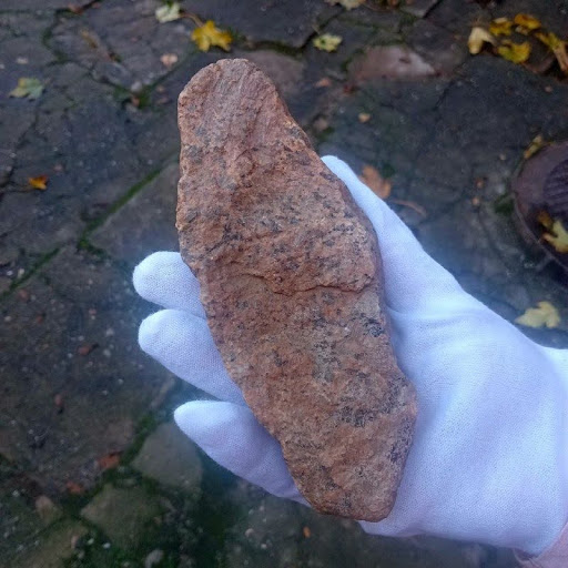
Anthropomorphic artifact “Woman with an Infant.” PHOTO: Nata Chernetska
To which period do you ultimately date the petroglyphs and the artifacts found?
Over the past two years, our opinion has not changed: we tentatively date the petroglyphs to the period ranging from the Neolithic (at the latest) to the Bronze Age (at the earliest). Anthropomorphic artifacts (churings) and ritual objects fit perfectly into the Neolithic context. Although the finds in the test pits beneath the cliff are tentatively dated to the Early or Middle Paleolithic, people of those eras were unlikely to have created such drawings on the walls. This is a later tradition. During the Neolithic, fishing flourished on full-flowing rivers, particularly on the Southern Bug. People used boats, settled on the islands, and, along with them, these cliffs, leaving sacred symbols on them.
What is the future of the findings and the island itself? Will the research continue?
Of course. First, we’re awaiting the geological analysis of the minerals and soils, and later a geologist will accompany us to the site. Second, we plan to conduct more extensive test pits and excavations at the site near the grotto. The layer there is not very thick—ranging from 20 to 50 centimeters—but these deposits must be fully investigated and sifted through. They may contain tiny flakes, charcoal, bones, pottery shards, flint tools, or lost jewelry. Or maybe something else?
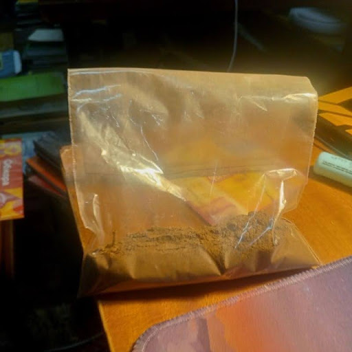
A soil sample from a test pit on Velykyi Island. PHOTO: Nata Chernetska
But here another serious problem arises. Today, the island and the Granite Pobuzhzhya region are widely perceived by people as “places of power.” Tourists come there to “recharge their energy,” tying ribbons and motanki to one of the boulders, which they call “The Serpent.” I understand that it’s beautiful and peaceful there, but this poses a threat to archaeology. Many tourists, while admiring the rocks, take “pretty pebbles” or other objects with them, thinking they’re just harmless souvenirs. This is how unique artifacts disappear, never to be discovered by humanity.
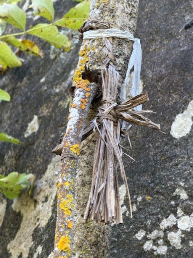
Locals consider the island a “place of power.” PHOTO: Oksana Hrytsyuta
That is precisely why we collected as much as possible of what was lying on the surface and could have been destroyed or stolen. At the same time, we do not consider it necessary to fanatically clear the entire island of moss and lichens in search of new carvings. Granite erodes over time, and any intervention has an impact. The images that have already been revealed to people and have become known must be officially introduced into scientific discourse, documented, studied, and preserved. The rest should be left under nature’s cover. Perhaps future generations will have more advanced, non-invasive technologies to study the petroglyphs without harming the images themselves or the surrounding environment.
Was there a moment during the excavations that forced you to completely rethink your previous understanding of this site?
Yes, the discovery of primitive-looking tools—examples from the Early or Middle Paleolithic—was completely unexpected. We hadn’t expected to find a layer dating back so far here at all (although our colleague Ihor Pistruil was really hoping for the Late Paleolithic).
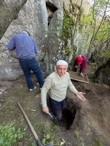
Igor Pistruil during the expedition. PHOTO: Oksana Hrytsyuta
If these are indeed tools from the Early or Middle Paleolithic, then the geographical situation at that time was completely different. Most likely, the island wasn’t an island at all back then, and there was land access to this area. After all, hundreds of thousands or even a million years have passed—the Early Paleolithic is an extremely ancient period.
Since then, the Southern Bug River, carving its way through granite, has significantly deepened its channel. Back then, the river could have been much shallower, allowing people to cross directly at a ford (incidentally, locals still wade across at certain spots today). So it was much easier for ancient people to get here than it was for us during our expedition.
Please explain in simple terms: what makes the archaeological heritage of this part of the Mykolaiv region unique compared to other regions of Ukraine?
Velykyi Island, like the Late Paleolithic sites of Anetivka-1, Anetivka-2, and others that our team has been studying for many years, is located in the Granite-Steppe Pobuzhzhia region. This is a natural complex, one of the oldest landmasses in Eurasia, and a unique geographical and geological zone on the edge of the Ukrainian Crystalline Shield.
In terms of archaeological characteristics, there aren’t many sites with petroglyphs in Ukraine. The largest and most famous is Kamyana Mohyla in Zaporizhzhia. It is currently under Russian occupation, and researchers do not know its actual state of preservation—the invaders are treating our heritage in a blatantly barbaric manner.
Kam’yana Mohyla is a unique site on the Molochna River. The sandstone cliffs there erode and crumble over time; even loud noises or vibrations can damage them. At one time, researchers studied the grottoes and preserved them using this same sand, revealing only select fragments during major international conferences for scholars to examine.
And now it turns out that similar rock art existed not only on the sandstones of Zaporizhzhia but also on the granites of the Pobuzhzhia region! And these are not isolated cases. For example, about ten years ago, we studied the area near the Mertvovod River. This is also the Granite-Steppe Pobuzhzhia region, home to the Aktovsky Canyon, also known as Devil’s Canyon. There are a vast number of rocks there that require a trained eye.
What are the most critical threats to these petroglyphs right now?
On the one hand, nature itself is destroying the site: heavy rains, humidity, and sharp temperature fluctuations are weathering and eroding the granite, causing entire boulders to break off the rock formations. On the other hand, there’s the human factor. The island is now widely regarded as a “place of power,” and unprepared tourists often behave unpredictably: they try to take a “souvenir pebble” with them, destroying the valuable context of the finds, or leave traces of vandalism. Moreover, such actions are dangerous for the travelers themselves: the terrain there is so complex and unstable that a careless step toward the edge of a boulder can easily dislodge it.
Where will the discovered artifacts be stored, and when can we expect the first scientific publications?
All the items found have already been brought back and will be officially transferred to the collections of the Odessa Archaeological Museum of the National Academy of Sciences of Ukraine for safekeeping, since that is where the core of our team is based. They will be included in a scientific report and published.
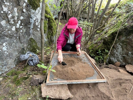
Alla Glavenchuk sifts soil from the test pit through a sieve. PHOTO: Oksana Hrytsyuta
The first publication regarding the anthropomorphic pebble (churinga) found two years ago has already been released in the proceedings of the Mykolaiv Regional Studies Conference. Full-length scientific papers based on the results of the current excavations will be published in about a year. This is a necessary process to introduce the site into the scientific community and draw the world’s attention to the unique heritage of the Pobuzhzhia region.