Меню
Соціальні мережі
Розділи
March 8, 2026, 6:51 p.m.
Amazing South: Secrets of the Kamianska Sich
This article also available in English52

IMAGES: Intent
The Kamianska Sich National Nature Park is a place of harmonious combination of original steppe nature and the glorious history of the Ukrainian Cossacks. It is a protected area of more than 122 square kilometers, which was established in 2019 on the right bank of the Dnipro River in the Beryslav district of Kherson region.
The story about this park continues the series "Amazing South", which has already covered the Dead Sea's competitor from Odesa region - the Kuyalnyk estuary, the protected pearl of Mykolaiv region - Buzky Gard, the birthplace of the Cossacks in Kherson region - Stanislav, the Muslim capital of Ukraine - Bakhchisarai and the underestimated health resort of Odesa region on the Budak Est uary and the ancient city of Mykolaiv region - Ochakiv.
The natural complex stretches along the coast of the former Kakhovka Reservoir, at the confluence of the Kamianka River with the mighty waters of the Dnipro, near the village of Respublikanets in Beryslav district. The park preserves unique steppe landscapes of gully systems, areas of the devastated reservoir, and historical and archaeological monuments of different eras - the remains of about 150 mounds, ancient settlements, manors, ancient monasteries, and the eponymous Zaporizhzhia Sich of the 18th century.
The village of Respublikanets is surrounded by diverse landscapes. On the one hand, there are picturesque steppe slopes, on the other - fields and vineyards. The coast of the former Kakhovka Reservoir is decorated with Cape Strelka. The Pugach Rock, which stands on the opposite side of the bay, adds a special atmosphere. This landscape creates a unique panorama.
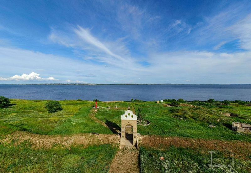
Kamianska Sich. PHOTO: Findaway
Flora and fauna of the park
The flora of the unique site of the Kamianska Sich Nature Reserve Fund includes more than 500 species of vascular plants, including 46 particularly valuable species under protection. 19 species of plants in the Park are listed in the Red Data Book of Ukraine and international conservation lists: Henning's astragalus, Volga ergot, Scythian drakes, Ukrainian feather grass, reticulated saffron, Buzky tulip, Dnipro feltwort, and others.
The fauna of the Kamianska Sich Nature Park is quite diverse, containing more than 90 species of rare fauna, many of which are rare vertebrate and invertebrate animals that are protected. Among them are the common spotted owl, great crested owl, red heron, and many others.
History of the ancient Beryslav region
The history of this territory dates back to prehistoric times. The rocky shores of the Kamianka gully remember how life was born on these lands. Archaeological excavations have uncovered Bronze Age burials near the village of Respublikanets. The remains of temporary settlements from the end of the second millennium BC were found on the Dnipro slope, including fragments of stucco pottery and animal bones. Traces of Scythian colonies (IV century BC) are found directly on Cape Strelka. One of the most interesting discoveries is the ruins of a small "late Scythian" settlement of Konsulove, dating from the first century BC - II century AD. The settlement had a square shape, an entrance from the west, and was equipped with stone buildings and a small citadel. Evidence of the Cherniakhivska culture, Old Russian and Golden Horde times (XII-XIV centuries) was also found on the cape. The remains of a Brodnytsia settlement of the X-XIII centuries were discovered on the territory of the village, and coins of the Crimean Khans of the Gerai were accidentally found at different times.
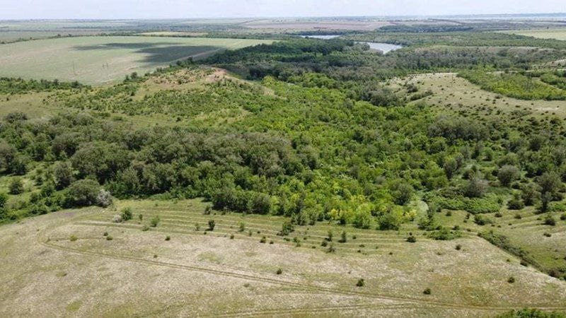
PHOTO: "Left Bank"
These lands have played an important role since ancient times, because a strategically significant object was located nearby - the Cairo (Kamianskyi) crossing of the Dnipro, which connected the right and left banks of the river. It was one of the five most convenient transports that passed through Cairo Island. Its presence is the reason for the rich history of the village of Respublikanets. As you know, river crossings have always been of great strategic importance. Cairo transportation was convenient only from the right bank to the left bank - downstream of the river channels. That is why the wagons on their way to the Crimea used the Cairo transportation, and on the way back they used the Kyzykerman transportation in Beryslav.
The large profits generated by the transportation led to the settlement of the surrounding area at different times. A small settlement existed not far from it during the XV-XVIII centuries. This is also reflected on maps of the XVII-XVIII centuries. One of the branches of the overland Black Sea route approached the Kamianka River from the right bank of the Dnipro. On the left bank of the Dnipro, opposite Kamianka, there was a large settlement called Rohat-Kerman or Rohat-Eski-Kerman, which means "Calm Old Fortress" or "Old Town" in Tatar. This fortification was apparently one of the two points located on both sides of the Cairo transportation.
All these archaeological finds confirm the centuries-old rich heritage of the Beryslav region.
The Cossack past is not forgotten
The lower reaches of the Dnipro River, where the present-day Kherson region is located, differ from other regions in that they have ancient Cossack roots. In total, three of the eight known Cossack Sichs were located on Kherson's land. One of the most famous is the Kamianska Sich, a historical and cultural site: the only monument to the Cossack Sich in Ukraine that has survived to this day in almost its original form. All three main components of its part have survived here: The kosh with its huts and treasuries, the Sich square; the surrounding area with production workshops, residential buildings, and an old Cossack cemetery, where the grave of the prominent kosh ataman Kostya Hordiienko with a mound mound, which is also a unique historical artifact, has been preserved. Archaeological excavations are underway in the park, which have resulted in the discovery of many Sich objects, as well as the remains of weapons and Cossack household items.
The history of the Kamianska Sich is directly related to the events of the national liberation struggle of the Ukrainian Cossacks and the patriotic elite under the command of Ivan Mazepa. In 1709, the Chortomlyk Sich ceased to exist as a result of its tragic destruction by the Russian troops of Peter the Great. At that time, the Zaporizhzhia Cossacks, led by Ataman Kost Hordienko, sought refuge outside of Russian influence. The alliance with the Swedish King Charles XII and Hetman Mazepa after the defeat of Poltava forced them to move to the border of the lands controlled by the Crimean Khanate in order to preserve their autonomy. This Sich was not an accidental camp, it became a strategic fortified center to protect against enemy raids.
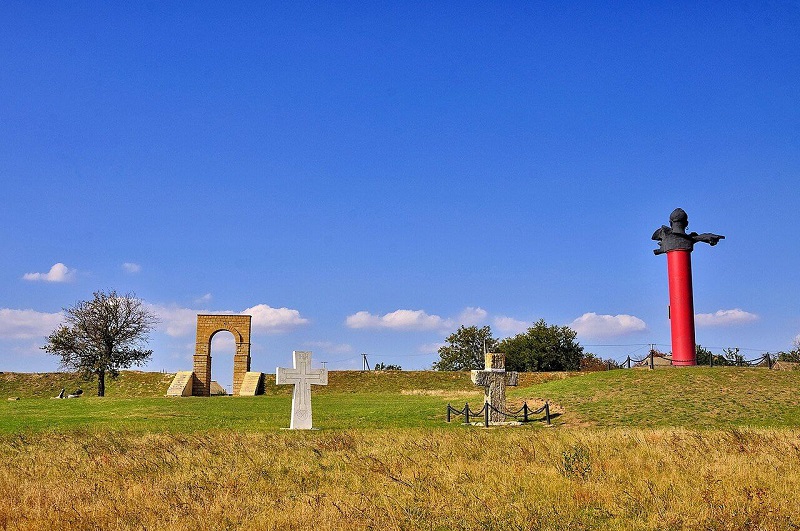
PHOTO: Wikipedia
Historical sources claim that the choice of the Sich's location was not accidental: the mouth of the Kamianka River provided natural protection and access to trade routes. The Cossacks, fleeing persecution, brought their rebellious spirit here and turned the rocky banks into a part of the Cossack community.
There are several versions of the history of the Stone Sich. Prince S. I. Myshetskyi, author of The Story of the Cossacks of Zaporizhzhia..., claims that after the defeat of the anti-Moscow uprising led by Hetman Mazepa and the destruction of the Chortomlyk Sich by order of Tsar Peter I in May 1709, the Sich was moved to Kamianka. Already in 1711, according to him, this Sich was destroyed by the Russians, after which the Cossacks were forced to move their capital to the Oleshky tract on the left bank of the Dnipro. Subsequently, the Sich was again moved to Kamianka, where it existed until the Cossacks returned to Moscow's protection in 1734.
The history of the Ukrainian Sich during the period of the Cossacks' stay under Crimean patronage is presented differently in the "Note to Posterity," compiled by order of one of the Cossack atamans in 1734. According to this official document, after the defeat of the Chortomlyk Sich, the Cossacks founded a new Sich in Oleshky, where they stayed for nineteen years. In 1728, they returned to Chortomlyk, where they stayed for two more years, and only in 1730 did they return to the Kamianka River.
The documents of those times, which are in the Russian Federation, were studied by historian V. I. Milchev. The researcher concluded that in the spring of 1711, a punitive detachment under the command of Colonel Ushakov failed to accomplish its task of destroying the Sich in Oleshky. Therefore, in order to somehow rehabilitate themselves in the eyes of the higher command, a part of the Russian army went down the Dnipro and burned a small Cossack settlement on the right bank of the river, near the Cairo crossing, which was presented in the report as the destruction of the "new" Sich itself. Archaeological finds in Kamianska Sich somewhat contradict this.
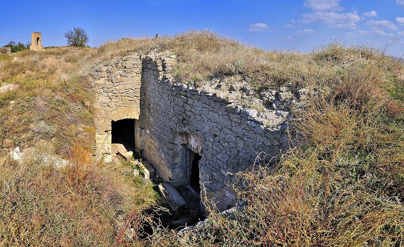
PHOTO: Wikipedia
Interesting facts:
- It is believed that Kamianska Sich is the birthplace of the Constitution. It was here that the articles of the Constitution of Pylyp Orlyk were discussed in 1710, before the delegation was sent to Bendery.
- Kamianska Sich had its own customs. The ataman collected customs duties from transportation on the Dnipro and Bug rivers. This indicates the developed economic activity of the Sich.
- During archaeological excavations on the territory of the Kamianna Sich park, Cossack coins with their own coats of arms were found.
- The Turkish coffee bowls found indicate that the Cossacks actively consumed coffee. Other drinks were served in other dishes.
- After the dam of the Kakhovka hydroelectric power station was blown up in 2023, the Kamianka River was restored and the landscape of the territories returned to its original appearance, which was still in the time of the Cossacks.
Consequences of Russian aggression against Ukraine
The Kamianska Sich Park is a relatively "young" nature reserve, having been established in 2019 and having existed in war for almost half of its life. According to experts, Russia' s full-scale invasion of Ukraine had a very negative impact on the park's ecosystems. It was occupied by the Russian invaders for 8 months in 2022 and was liberated by the Armed Forces of Ukraine.
At the time of liberation, almost the entire territory of Kamianska Sich was mined; during the occupation, dozens of fires occurred here, partially destroying the steppe vegetation. The construction of fortifications, dugouts, trenches, and caponiers of various sizes also caused great damage to the natural cover and Cossack monuments. The Russian occupiers also cut down a large number of trees during their stay in the national park. They left behind huge landfills.
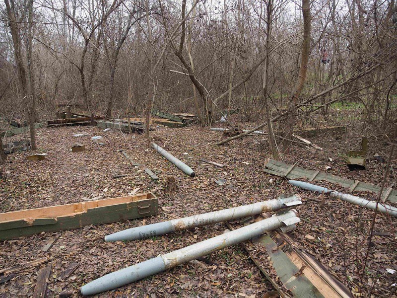
The consequences of Russian aggression. PHOTO: Faceebok / Ivan Moysiyenko
The effect of all these destructive factors is also reflected in the biota: many species of plants and animals were destroyed. Even now, after the liberation, the territory is still on the contact line, so it is regularly shelled and remotely mined.
According to experts, it may now take hundreds of years to restore the steppe and gradually change the ecosystem so that it returns to the state it was in before in the untouched areas of the reserve.
Getting to Kamianska Sich
Attention: due to the proximity to the combat zone and demining, visits are prohibited as they may be restricted or dangerous!
Kamianska Sich is located in the village of Respublikanets, Beryslav district, Kherson region.
Ways to get there
- By your own car: The most convenient option. From Kherson, you need to follow the T0403 highway in the direction of Beryslav, and then turn to the village of Respublianets.
- Important: Roads in the area may be in poor condition or damaged as a result of hostilities.
- By public transport: You can use the buses that run from Kherson to Beryslav or the surrounding villages. From Beryslav to the village of Respublikanets, you will have to take a taxi or look for local transportation. Landmarks: Remnants of earthen ramparts and a memorial cross to the kosh ataman Kostyantyn Hordiienko.
- By water: Before the Kakhovka hydroelectric power station was blown up, there were plans and routes for water transportation, but now, due to the change in the Dnipro riverbed and the security situation, this option is impossible.
Юлія Сичова